

Our Work
Resources and Products Produced for Partner Communities
About
Featured on this page are examples of resources and products developed by the DRIP team in collaboration with our partner communities.
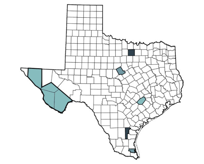
Between 2022-2024, DRIP worked with ten partner communities experiencing chronic and acute flooding events across six diverse regions in the state to create practical tools, including customized flood risk maps, tailored to local needs. Two communities—Fort Hancock and Wise County—were selected for additional, customized projects to serve as proof-of-concepts with potential for broader application. These efforts included the Wise County Flood Depth Surface Elevation Visualization Project and the Hudspeth County/Fort Hancock Community Flood Knowledge Collection Project.
For a deeper look at our work, we encourage you to explore our blog. The blog offers a nuanced perspective on the challenges facing many Texas communities experiencing chronic and acute flooding events, and the DRIP team’s collaborations with our partner communities.
DRIP Customized Flood Risk Maps
Used for Planning Purposes OnlyFrom 2022 – 2024, the DRIP team produced a series of customized paper and PDF format maps based on community feedback about their priorities for visualizing flood risk information and their requested unique modifications. Each community also received a data reference sheet containing an overview of the data sources and the full underlying data packages upon request.

Partnered Communities
Below is a list of communities DRIP partnered with to produce customized flood risk maps. To request a copy of a map, email [email protected].
Upper Rio Grande Valley
- Upper Rio Grande Valley: Tri County
- Brewster County
- Jeff Davis County
- Presidio County
- City of Alpine
- City of Fort Davis
- City of Presidio
Comanche County
- Comanche County
- City of Comanche
- City of DeLeon
Hudspeth County
- Hudspeth County
- City of Dell City
- City of Desert Haven
- City of Fort Hancock
- City of Sierra Blanca
Jim Wells County
- Jim Wells County
- City of Orange Grove
- City of Premont
Willacy County
- Willacy County
- City of Lasara
Wise County
- Wise County

Hudspeth County/Fort Hancock
Community Flood Knowledge Collection ProjectThis project focused on developing a process to collect community-held knowledge (such as photos; verbal descriptions of water lines and dates of major storms leading to flooding; and verbal identification of areas/locations prone to flooding, etc.) to inform mapping and modeling products. The main product was a systematic collection of data focused on documenting and describing flooding in this flash-flood vulnerable community, and a GIS Data Viewer.
The project included the following components

Data Collection
Worked with the community to collect flood data to help support grant and funding applications and inform policy and planning decisions. This door-to-door data collection effort consisted of training community members to build community-driven flood hazard maps.

Aerial Imagery
Collection of aerial images of the community via drone to better map and understand land use/land cover (LULC) and existing, unofficial, and/or modified local drainage.

Tools
Hudspeth County now has the ability to interactively view flood hazard data within their community through a simple GIS interface, which uses official flood data sources and was combined with other information, such as the location of structures.

Recommendations
Recommendations were provided for potential future uses of the collected data for improved modeling or other risk visualization techniques for the community.
Wise County
Flood Depth Surface Elevation VisualizationThe DRIP team provided Wise County with high resolution flood hazard map products based on the most current flood frequency studies. This tool, which consisted of both interactive and paper-based maps, allows county administrators to visualize and/or extract flood depth and elevation data over particular areas or points of interest, and assists with decision making as well as policy and scenario planning.

The project included the following components

Tools
Interactive flood hazard maps that allow users to visualize flood depths and elevations across the county and at specific points of interest.

Flood Visualization
Paper-based map products to support planning, communication, and use in settings where digital tools may not be available or practical.

Resources
A curated inventory of relevant data sources that the county can access independently as they work towards addressing their flooding issues.
Blog
Welcome to our blog! Explore our posts to learn more about DRIP’s work and the challenges facing our partner communities.

Fort Hancock, also portrayed in our previous blog posts, is a community of hard-working individuals. Even though this is a desert, it is also a flood-prone area. But people love their town. They like its quiet environment and enjoy harmonious relations with their neighbors. Many people in this community are highly motivated to serve one…

Arriving in Fort Hancock, Texas for the first time, it was clear to us that this community was in an entirely different flood situation than most of the communities we typically work with. Approximately 55 miles southeast from the rapidly developing city of El Paso, Texas and just off highway I-10, the Fort Hancock colonias…

Imagine being new in a community. Regardless of whether you rent or own your home, you need to get your utilities—e.g., water, power, trash—connected and an account set up in your name. In many places in the US, if you build a new patio or make extensions to your home, you need to get proper…